
Contributions from UNIGE/ISE to the Group on Earth Observations and the Global Earth Observation System of Systems
How well do we know our environment?
To understand, mitigate and adapt to environmental changes, accurate geospatial and statistical data about our environment is necessary. Earth observations (EO) from satellite, airborne and drone sensors, together with in-situ measurements can provide reliable information over long periods of time at different geographical scales (e.g., local to global). EO contributes to defining and implementing evidence-based environmental policies; to reporting on natural capital, ecosystem services and other environmental components; and to monitoring, through indicators combined with socio-economic data, progress towards achieving environmental goals, such as the United Nations Sustainable Development Goals.
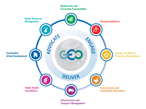
The Group on Earth Observations (GEO) is an intergovernmental organization based in Geneva that is working to improve the availability, access and use of Earth observations for the benefit of society. GEO works to actively improve and coordinate global EO systems and promote broad, open data sharing. GEO is a partnership of 105 national government Members and 115 Participating Organizations that envisions a future where decisions and actions for the benefit of humankind are informed by coordinated, comprehensive and sustained Earth observations. GEO is a unique global network connecting government institutions, academic and research institutions, data providers, businesses, engineers, scientists and experts to create innovative solutions to global challenges at a time of exponential data growth, human development and climate change that transcend national and disciplinary boundaries. The unprecedented global collaboration of experts helps identify gaps and reduce duplication in the areas of sustainable development and sound environmental management. GEO works across eight Societal Benefit Areas (Biodiversity and Ecosystem Sustainability; Disaster Resilience; Energy and Mineral Resources Management; Food Security and Sustainable Agriculture; Public Health Surveillance; Sustainable Urban Development; Infrastructure and Transport Management; Water Resource Management) to translate Earth Observations into support for decision-making with climate as a cross-cutting topic for all SBAs. GEO’s global engagement priorities include supporting the UN 2030 Agenda for Sustainable Development, the Paris Agreement on Climate, and the Sendai Framework for Disaster Risk Reduction.
A central part of GEO’s Mission is to build the Global Earth Observation System of Systems (GEOSS) the aim of which is to integrate observing and data sharing systems by connecting existing infrastructures using common standards. There are more than 400 million open data resources in GEOSS from more than 150 national and regional providers. GEOSS is a set of coordinated, independent Earth observation, information and processing systems that interact and provide access to diverse information for a broad range of users in both public and private sectors. GEOSS links these systems to strengthen the monitoring of the state of the Earth. It facilitates the sharing of environmental data and information collected from the large array of observing systems contributed by countries and organizations within GEO. Further, GEOSS ensures that these data are accessible, of identified quality and provenance, and interoperable to support the development of tools and the delivery of information services. Thus, GEOSS increases our understanding of Earth processes and enhances predictive capabilities that underpin sound decision-making: it provides access to data, information and knowledge to a wide variety of users.
How ISE is contributing to GEO?
The University of Geneva/Institute for Environmental Sciences is significantly contributing to GEO/GEOSS through various European Union (EU) and Swiss funded research projects. Since 2009 we have worked on eight projects among which two were large EU projects that we coordinated: enviroGRIDS was a seminal project that modeled for the first time the hydrology of the entire Black Sea catchment from available Earth observations; and the EOPower that improved conditions for sustainable economic development through the increased use of Earth observation products and services for environmental applications.
In addition, through the GRID partnership agreement between the UN Environment, the Swiss Federal Office for the Environment, and the University of Geneva, other projects were developed such as the Global Risk Data Platform on global risk from natural hazards; Transforming Essential Climate and Biodiversity Variables into information products; and the MAP-X platform for monitoring the sustainable use of natural resources.
What ISE is currently doing for GEO?
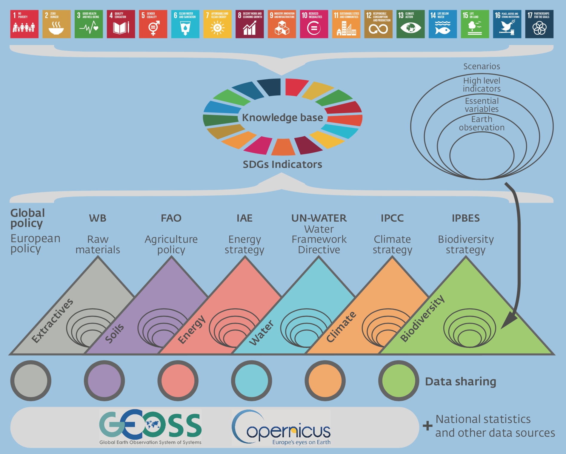
The H2020 GEOEssential is a three years project that is aiming to address the need for trusted sources of data and information to monitor progress made on environmental conditions towards policy targets. The project will demonstrate the feasibility of Essential Variables, as a response to the need for a more coordinated approach to global environmental (e.g., climate, biodiversity) observations. Criteria to identify EVs include relevance in characterizing a system and its changes, feasibility of observing and deriving the variables, and cost effectiveness, across GEO Societal Benefit Areas. It will create cross-thematic workflows to evaluate, predict and monitor natural resources to inform the Sustainable Development Goals via Earth observations. Existing structures and platforms will be analyzed in order to identify substantial gaps and synergies for addressing the needs of environmental policy in agriculture, soil, water, biodiversity, energy, light and raw materials.
The second project is called the Swiss Data Cube (SDC), it is supporting the Swiss government for environmental monitoring and reporting. This project will enable Swiss scientific institutions (e.g., GRID, UNIGE, UNIZH, WSL) to bring new insights and improve the knowledge on the Swiss environment using EO data. Data Cubes are a new way of processing and analyzing vast amounts of historical and current Earth observation data very quickly to realize the full potential of EO data by lowering the barriers caused by these big data challenges and providing access to large spatio-temporal data in an analysis ready form. UN Environment/GRID-Geneva and the University of Geneva are currently building the SDC following the initial work done by Geoscience Australia. The “Australian Data Cube” (part of Digital Earth Australia) is a new way for organizing EO data (especially Landsat satellite data) by gathering all satellite images through space and time for a given period over a dedicated region. This is a change of paradigm in the way that remote sensing data are being organized for delivering it to end-users. This collaboration allows the vision and implementation of the SDC concept to be advanced and is positioning Switzerland as a pioneer and leading country on this technology for monitoring the environment of our country in space and time from EO. Switzerland is the second country in the world (and the only in Europe) to have an EO Data Cube.
The SDC contains 33 years of Landsat 5, 7, 8 and Sentinel 2-A/B Analysis Ready Data (1984-2017) corresponding to more than 6500 images at 10m resolution, a data volume of 3TB, and a total number of observations that exceed 110b billions.
Since 2011, our groups have published more than 30 papers on Earth Observations and GEO/GEOSS. A full list of contributions can be found on our website.
From an institutional perspective, several ISE members are actively involved in various GEO initiatives, activities and tasks of the GEO Work Programme. We are currently involved in:
- Earth Observations in Service of the 2030 Agenda for Sustainable Development;
- GEOSS-EVOLVE: co-chairing WP6 on Community Portals;
- GEOSS Common Infrastructure Operations;
- Capacity Building Coordination;
- GEOSS Architecture Implementation Pilot; and
- Organizing Committee of the annual GEO Data Providers Workshops.
We are also part of the Swiss coordination group on GEO/GEOSS lead by the FOEN and have been part of the official Swiss delegation at various GEO plenaries (2010, 2011, 2012, 2014, 2015, 2017) and through our enviroGRIDS & ARPEGEO projects enabled the inclusion of Armenia and Georgia as new GEO country Members.
We are organizing the yearly European GEO workshop at University Carl- Vogt from September 12-14 gathering the best European experts in the field to build the next generation of projects under the umbrella of EUROGEOSS, the European regional initiative for GEOSS.
Where can you learn more about GEO and the challenges of EO data sharing?
To explain the benefits of broad open data sharing, we produced a movie in the frame of the enviroGRIDS project called “The Story of Data on the Environment”.
Another important contribution stands in tools developed to facilitate discovery, access and use of Earth Observations data and to build the capacities of scientists to use these tools. We developed the "Bringing GEOSS services into practice" workshop that aims at teaching how to configure, use and deploy a set of open source software to set up a spatial data infrastructure (SDI). Trainees will learn how to publish and share data and metadata using OGC and ISO standards and how to register services into the Global Earth Observation System of Systems (GEOSS). All the material is freely available.
We also contributed to the development of the GEOCAB portal in the frame of the EOPOWER and IASON projects. This Capacity Building resources portal has been officially endorsed by the GEO Secretariat three years ago. The portal is currently being developed to be more usable and accessible.
We are also participating in supporting the GEOSS platform itself and led the development of the new component for facilitating the registration of new data providers within GEOSS. We work very closely with the GEOSS Platform team at the Italian National Research Centre (CNR) and the European Space Agency (ESA), as well as the GEO Secretariat.
Additionally, we are proud of our new Certificate of Advanced Studies on Geomatics for a Sustainable Environment that will take place from June 11-22 2018.
Finally, we are excited to announce that we are preparing an exposition at University Carl-Vogt from August 27 to September 16 entitled “One Planet – Several GEO solutions”. Everyone is invited!
We encourage other universities and research institutions to engage in the global GEO activities and help support their national government endeavours in Earth observations. As you can see the rewards are significant for all parties involved and today, more than ever, we need a much greater understanding of our planet to be able to plan and deliver effective mitigation and adaptation strategies.
Acknowledgements:
We wish to gratefully acknowledge the work of the enviroSPACE and GRID teams that contributed to all these projects.

Gregory Giuliani
Dr. Gregory Giuliani is a lecturer in Earth Observations and Spatial Data Infrastructure at the University of Geneva/Institute for Environmental Sciences. He is sharing his time with UN Environment/GRID-Geneva where he is the SDI Officer and leads the Swiss Data Cube project. Dr. Giuliani is particularly interested in how Earth observations can be used to monitor and assess environmental changes and support sustainable development.

Anthony Lehmann
Prof. Anthony Lehmann is associate professor, vice-director of ISE and leading the enviroSPACE team on Spatial Predictions and Analyses in Complex Environment. His main interest if to transform raw data from EO into useful indicators to improve our capacity to inform environmental policy. He is mostly working on biodiversity and hydrology to measure these natural capitals and their ecosystems services to inform spatially the Nexus of Climate-Water-Food-Energy-Ecosystems and the Broader Sustainable Development Goals.

Steven Ramage
Steven Ramage leads global stakeholder engagement and external relations for the intergovernmental Group on Earth Observations (GEO). Steven’s role is to work on the GEO priorities relating to the role of Earth observations supporting international policy, including the Sendai Framework for Disaster Risk Reduction, the Paris Agreement for Climate and the UN 2030 Agenda for Sustainable Development. Steven is a member of the Global Advisory Council for the Open Geospatial Consortium (OGC) and a Fellow of the Royal Geographical Society (RGS) and was recently appointed Visiting Lecturer at ISE.
Nous vous suggérons


Swiss Data Cube
Earth Observation for monitoring the environment of Switzerland in space and time.